File:Communist countries.PNG
Jump to navigation
Jump to search
Size of this preview: 800 × 351 pixels. Other resolutions: 320 × 140 pixels | 640 × 281 pixels | 1,425 × 625 pixels.
Original file (1,425 × 625 pixels, file size: 33 KB, MIME type: image/png)
|
|
This is a file from the Wikimedia Commons |

|
This file requires updating because: South Sudan In doing so, you could add a timestamp to the file.
|

|
File:Communist countries.svg is a vector version of this file. It should be used in place of this PNG file.
File:Communist countries.PNG → File:Communist countries.svg
For more information, see Help:SVG. |
 |
Summary
| Description |
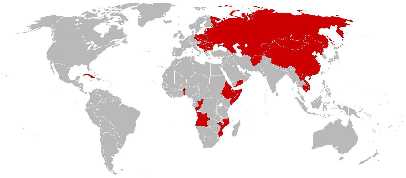
English: An anachronous map of countries (using present-day borders) that have been ruled by a one-party Marxist-Leninist state at some point in their history.
By the time of the 1979-1983 Communist Grenada, all the colored nations above were simultaneously Communist-controlled. |
| Source | File:BlankMap-World-1985.png |
| Author | |
| Other versions | File:Communist countries 1979-1983.png |
Licensing
| I, the copyright holder of this work, release this work into the public domain. This applies worldwide. In some countries this may not be legally possible; if so: I grant anyone the right to use this work for any purpose, without any conditions, unless such conditions are required by law. |
File history
Click on a date/time to view the file as it appeared at that time.
| Date/Time | Thumbnail | Dimensions | User | Comment | |
|---|---|---|---|---|---|
| current | 15:05, 3 March 2014 | | 1,425 × 625 (33 KB) | Hallel | Reverted to version as of 10:22, 8 April 2010 |
| 14:00, 13 November 2012 |  | 1,425 × 625 (56 KB) | Hallel | Adding to Sandinista Nicaragua to the map. See: [http://en.wikipedia.org/wiki/Nicaraguan_Revolution Nicaraguan Revolution] | |
| 10:22, 8 April 2010 |  | 1,425 × 625 (33 KB) | MaGioZal | Added 1979-1983 [http://en.wikipedia.org/wiki/People%27s_Revolutionary_Government Communist Grenada]. | |
| 03:03, 15 January 2010 |  | 1,425 × 625 (26 KB) | MaGioZal | Changed from current borders to 1985 borders, when all the nations colored in red were Communist one-party states. | |
| 17:16, 13 December 2007 |  | 1,425 × 625 (26 KB) | Mahahahaneapneap | pngcrushed | |
| 08:40, 27 February 2007 |  | 1,425 × 625 (90 KB) | Nikodemos | ||
| 00:32, 7 January 2007 |  | 1,425 × 625 (56 KB) | Sesel | new version of previous map with geographic corrections and modifications to more closely conform to the map's description | |
| 23:37, 6 January 2007 |  | 1,425 × 625 (56 KB) | Zanturaeon~commonswiki | Description:A map of Marxist-Leninist single-party "Communist" socialist states and non-Marxist-Leninist, single-party "Communist" socialist states that exist or have existed in the past. The former is in red, the latter is in light-red. Social-democratic | |
| 23:32, 6 January 2007 |  | 1,425 × 625 (56 KB) | Zanturaeon~commonswiki | Description:A map of Marxist-Leninist single-party "Communist" socialist states and non-Marxist-Leninist, single-party "Communist" socialist states that exist or have existed in the past. The former is in red, the latter is in light-red. Social-democratic |
File usage
The following 2 pages use this file:
Global file usage
The following other wikis use this file:
- Usage on da.wikipedia.org
- Usage on pt.wikipedia.org
- Usage on ru.wikipedia.org
- Usage on sk.wikipedia.org
- Usage on te.wikipedia.org
- Usage on uk.wikipedia.org